
Heavy rains result in falls at local lake
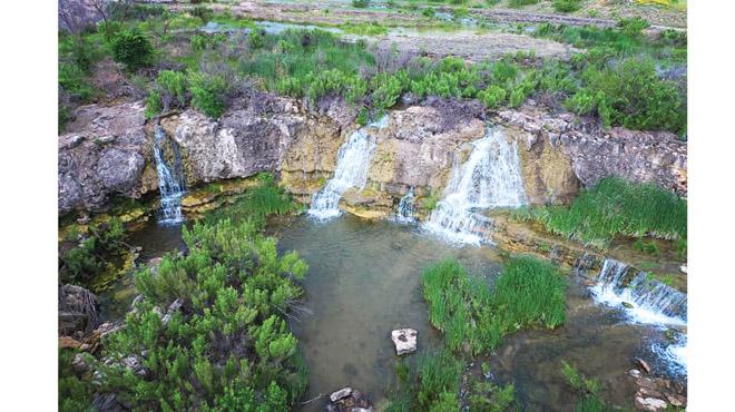
Video footage posted on Facebook last week by Albany 2012 graduate Josh Hudman showing multiple waterfalls cascading 15 or more feet down a rock embankment to plunge into a deep pool of water surrounded by lush green foliage was, to the surprise of many, actually filmed last Thursday, May 2, near the spillway at McCarty Lake.
The destination vacation worthy scene is on privately owned land only a few miles southwest of Albany.
“We’ve had so much rain recently that the Albany lake is full and overflowing,” said Hudman. “I’ve seen it look like this several times while I was growing up, usually after a few big rains in the spring, but it’s been a while.”
The last quarter of 2018 was the wettest one on record in Albany according to the National Weather Service. Over 17 inches of rain fell during the final three months of last year, compared to the historic average of less than seven inches during that same time frame.
January, February, and March of 2019 were a little drier than normal. However, 4.72 inches of rain in April followed by 0.78 inches of rain on May 1 created enough runoff to be noticed, especially if, like Hudman, one knew from past experience just where to look.
Hudman filmed the footage using a drone.
According to Hudman, the lake is full, but is not visible in the clip. The water was flowing over the spillway into the Salt Prong Fork of Hubbard Creek and will eventually end up in Hubbard Creek Lake.
“Once it stops raining, it doesn’t take many days for the waterfalls to stop flowing,” Hudman said.
According to Albany water manager Chuck Sheppard, the lake fills up relatively fast and goes down fairly quickly. The spillway is just to the northeast of the dam, between the dam and County Road 147.
Sheppard added that the spillway itself is a fairly flat rock area.
“The water in the lake belongs to Albany, and the dam also belongs to the city,” Sheppard said. “But the landowners’ property goes all the way to the water’s edge, no matter the level of the lake at the time, so there is very limited public access to the lake.”
He explained that fishermen and boaters often carry small boats from their vehicles from the spillway area into the water, and that’s generally acceptable to landowners.
However, there is no longer a privately owned boat ramp or dock that is available for public use as there was in the past, he said, and there is definitely no public camping area.
Sheppard added that although in the past, landowners have allowed the general public to use the lake, the area became littered with broken glass and other trash, so the landowners no longer allow public use of their land.
According to the Texas Parks and Wildlife Department Big Country Angler’s Guide published in 2011, the 188 acre lake does not have any facilities, the two boat launching areas are unimproved, and the dirt road leading to the lake can be bad at times.
The Abilene Inland Fisheries District Office had a contour map of the lake available, and they managed the reservoir as recently as 2011.
