
2019 starts colds, ends with moderate temps

By Kathy Thomson
Twenty-nineteen started off cold, with temperatures unwilling to climb above freezing until Jan. 3, but the year ended on a warm note, with unusually mild temperatures the final month and a half.
During the course of the year, the weather was typical for this part of West Texas.
A late freeze surprised early blooming trees in March.
A gully washer grabbed headlines in April, another storm relocated Polo on the Prairie in May, and a lightning strike started a house fire in July.
Later in the year, tinder dry forage erupted into several large grass fires in August and September.
No measurable snow occurred in 2019, although sleet and ice fell in small amounts. The last official significant snowfall in Albany was over four years ago, on Dec. 27, 2015.
The coldest day of the year was Monday, Nov. 11, when a strong norther dropped the “feels like temperature” in Albany to four degrees, according to KTAB, and thermometers read a slim 17 degrees overnight.
Total rainfall for 2019 was 29.69 inches, which was a little over two and a half inches above the historic average of 26.96.
The wettest year on record occurred in 1941, when 47.01 inches filled the water gauges; while the driest year saw only 11.07 inches during the entire year of 1956.
Levels at Hubbard Creek Lake dropped from 100 percent full on Jan. 1, 2019 to 87.3 percent full on Dec. 31, leaving the reservoir at 1180.65 feet of elevation at the close of 2019.
2019 in Review
The first month of 2019 saw moisture right at the average of 1.16, with January precipitation totals of 1.17 inches.
February and March were drier than normal, with totals of 0.57 and 1.10 respectively, compared to the historic mean of 1.46 for February and 1.64 for March; however, the next three months more than made up for the deficit.
Spring rainfall totals of 4.72 inches in April, 7.46 in May, and 4.91 in June were all above their respective means of 2.63, 3.91, and 3.04 inches.
The remaining months of the year had below average rainfall, with the exception of November.
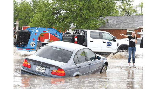
Although May was the wettest month of the year, the cloudburst on April 23 dropped over two and a half inches of rain in a short time, washing a car off the road and into the culvert in front of the Depot, and flooding water into several downtown businesses.
February was the driest month of 2019.
Temperature
Extremes
Although there were the expected extremes, temperatures throughout the majority of the year were more moderate.
The last freeze of the winter season was on March 31, very close to the 117-year average, with the last freeze usually occurring around March 29.
Triple digits were only recorded in the month of August. However, once the dog days of summer started, the weather stayed persistently hot.
One hundred degrees on Aug. 6 was followed by triple digit temps for over a week, two days of readings in the upper 90s, then four more sweltering days with triple digits. From Aug. 20-24, the afternoon highs moderated slightly, falling into the mid and upper 90s before climbing back to 100 degrees on Aug. 25.
The hottest day of the year was Aug. 26 when the mercury topped out at a scorching 106 degrees Fahrenheit.
The average day of the first freeze in Albany is Nov. 5, but cold weather came in earlier this fall, when the official thermometer dropped to 32 degrees on Oct. 12 before rebounding to more seasonable weather for a couple of weeks. Frigid temperatures returned late in October, with lows in the mid 30s from Oct. 24-29, followed by a hard freeze on Oct. 30 and 31. The 22 degree low on Halloween shattered the previous record for that date of 28 degrees which had been recorded in 1906, 1991, and 1993.
Temperatures dropped even lower in November, with night time lows of 17 degrees on both Nov. 11 and 12.
Winter Forecast
Forecasters at NOAA’s Climate Prediction Center issued a U.S. Winter Outlook favoring warmer weather with an average amount of precipitation in this region.
“Without either El Niño or La Niña conditions, short-term climate patterns like the Arctic Oscillation will drive winter weather and could result in large swings in temperature and precipitation,” said Mike Halpert, deputy director of NOAA’s Climate Prediction Center.
